


Voting District 10555, Kern County, California
About
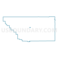
Outline

Summary
| Unique Area Identifier | 531605 |
| Name | Voting District 10555 |
| County | Kern County |
| State | California |
| Area (square miles) | 1.99 |
| Land Area (square miles) | 1.99 |
| Water Area (square miles) | 0.00 |
| % of Land Area | 100.00 |
| % of Water Area | 0.00 |
| Latitude of the Internal Point | 35.36188460 |
| Longtitude of the Internal Point | -118.86074750 |
Maps


Graphs
Select a template below for downloading or customizing gragh for Voting District 10555, Kern County, California


Neighbors
Neighoring Voting District (by Name) Neighboring Voting District on the Map
- Voting District 10510, Kern County, CA
- Voting District 10530, Kern County, CA
- Voting District 10531, Kern County, CA
- Voting District 10550, Kern County, CA
- Voting District 10560, Kern County, CA
- Voting District 10565, Kern County, CA
- Voting District 10570, Kern County, CA
- Voting District 30410, Kern County, CA
- Voting District 30420, Kern County, CA
- Voting District 50160, Kern County, CA
- Voting District 50185, Kern County, CA
- Voting District 50925, Kern County, CA
- Voting District 50930, Kern County, CA
Top 10 Neighboring County Subdivision (by Population) Neighboring County Subdivision on the Map
Top 10 Neighboring Place (by Population) Neighboring Place on the Map
Top 10 Neighboring Elementary School District (by Population) Neighboring Elementary School District on the Map
- Bakersfield City Elementary School District, CA (185,976)
- Edison Elementary School District, CA (5,899)